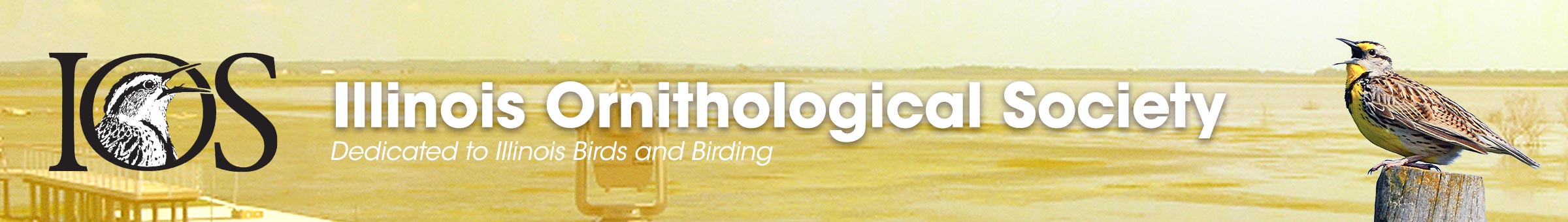
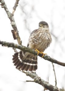
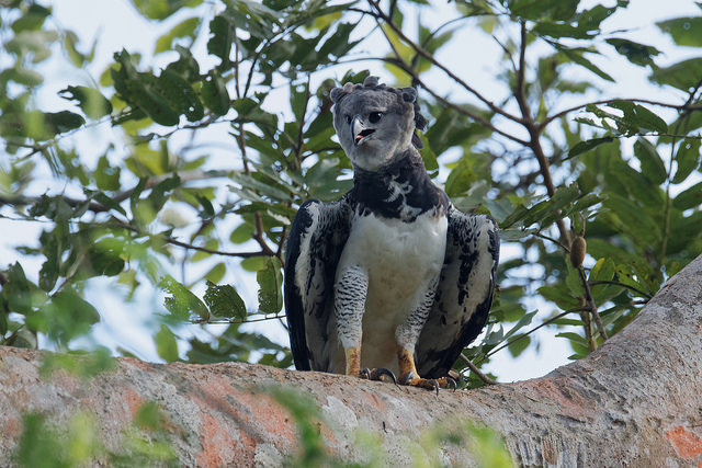
First cycle Iceland Gull (Larus glaucoides thayeri),formerly Thayer’s Gull by Matthew Cvetas
Since the American Ornithological Society (AOS) issued its 58th Supplement to its Check-list of North American Birds in which Thayer’s Gull was relegated to a subspecies of Iceland Gull, there have been a number of questions from the Illinois birding community about the handling of Thayer’s Gull with regards to list submissions. The Listers Corner Committee (with the approval of the IOS Board) will be handling the Thayer’s Gull question in this manner:
Thayer’s Gull will be countable for all 2017 year lists (state, county, etc.). Technically, one shouldn’t count it if it is first found after July, when the IOS Records Committee amended the official state list. See the official Illinois State List of Birds on the IOS Web site.
Thayer’s Gull will be countable for all Big Days and Big Months through July 2017, but not afterwards.
Thayer’s Gull should not be included with any submitted life lists (state, regional, county, sites, buddy, etc.). This pertains to any total submitted for inclusion in the 2017 Listers Corner.
The Listers Corner Committee will not be going back and vetting any lists from the past. Even though we know for certain that some birders have Thayer’s on their lists, it would be impossible to apply retroactive adjustments in any kind of equitable manner. If a birder does not submit an updated number, the number on record will not be changed.
Black-bellied Whistling-Duck: Rock Island (North) – On August 7th, Steve Freed reported a Black-bellied Whistling-Duck in the Zuma Creek Flats area of Rock Island County just southeast of the I-80 and I-88 interchange.
Wood Stork: Alexander (South) – A Wood Stork was photographed in flight at Sexton Creek Wetlands in Alexander County on August 5th.
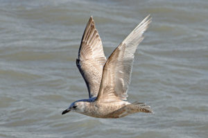
Neotropic Cormorant: Moultrie (Central) – Ron Bradley photographed a Neotropic Cormorant at Bruce West Access of Lake Shelbyville, Moultrie County on August 4th.
Black-bellied Whistling-Duck: Carroll (North) – On July 22nd, Ethan and Cindy Brown have found a Black-bellied Whistling-Duck along Army Depot Rd. near the entrance to the Lost Mound Unit of the Upper Mississippi River National Wildlife Refuge in Carroll County.
Ruff: Mason (Central) – On July 18th, Colin Dobson found a Ruff at the pool south of Chain Lake, at Sanganois State Fish and Wildlife Area in Mason County.
DOWITCHER BASICS
Dowitchers are large-bodied, short-legged migratory shorebirds with extremely long bills relative to body length. In general, dowitchers (including juveniles) have warm orangeish or reddish underparts from late spring through summer and early fall, molting to cold gray upperparts with whitish underparts from late fall through winter and early spring. All feed belly-deep in shallow water on mud flats, probing the mud with a stitching “sewing machine” motion of their bills. Flight is purposeful and direct (often in small flocks). In flight, all show pointed wings and a distinctive and conspicuous wedge-shaped white rump patch extending all the way up the back.
The difficulties arise when trying to distinguish the two similar species that occur as migrants. To clarify, only two forms are expected in Illinois: the monotypic Long-billed Dowitcher (Limnodromus scolopaceus), and the “prairie race” Short-billed Dowitcher (Limnodromus griseus hendersoni). For brevity, Long-billed will be referred to as LBDO, and Short-billed (hendersoni “prairie race” ONLY) will be referred to as SBDO. Although it is possible that other forms of SBDO may occasionally occur as vagrants in Illinois, I am unaware of any accepted records of SBDO forms other than hendersoni.
CALLS
The most reliable way to distinguish the two forms year-round is by their diagnostic calls. LBDO flight call is a sharp “keek” given singly or in rapid series. SBDO flight call is a hollow, mellow “tu-tu-tu.” LBDO also often engages in soft chatter while foraging, unlike SBDO.
MIGRATION ENVELOPES
LBDO has a more northerly distribution (breeds in tundra of Alaska & northern Canada, winters in southern U.S. and Mexico). SBDO has a more southerly distribution (breeds in the prairie provinces of Canada, winters as far south as the West Indies, Central America, and northern South America). Therefore, it follows logically (based on distance traveled) that LBDO arrives earlier than SBDO in spring and conversely, later in fall than SBDO. April dowitchers are almost invariably LBDO. SBDO arrives later in spring, usually not until May and arrive in fall by early July.
BILL LENGTH
Per Paulson’s “Shorebirds of the Pacific Northwest” (1993), LBDO bill length ranges from 54-81 mm; SBDO bill length ranges from 51-69 mm. Therefore, dowitchers with very short bills CANNOT be safely identified to species based on that character alone. On the other hand, dowitchers with bill length at the long end of the spectrum can be safely identified as LBDO, especially if other dowitchers are nearby for comparison.
STRUCTURE
LBDO averages chunkier than SBDO, often (but not always) showing a rounded back and belly (as if it had swallowed a grapefruit). LBDO bill also averages longer, thinner-based, finer-tipped, and straighter than SBDO, but there is much variation between the two species.
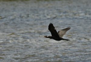
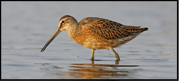
SPRING DOWITCHER IDENTIFICATION
For all dowitcher identification, it is important to have a good grasp of bird topography and to have a decent understanding of terms like “tertials,” “scapulars,” and “flanks.” During the spring, all dowitchers are adults or near-adults that are either transitioning into breeding plumage or have attained full breeding plumage. Although it is true that LBDO in full breeding plumage have dark, brick-red underparts from throat to vent (more orange with some white in vent in SBDO), remember that spring LBDO migrants seen in Illinois are often still in transitioning molt and show a considerable amount of white on the underparts.
Transitioning adult LBDO (left) and hendersoni SBDO (right) photographed in April by Kevin Karlson.
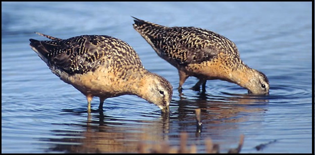
The most solid plumage clue one can use in separating spring adults (in fresh breeding or near-breeding plumage) of LBDO from hendersoni SBDO is the PATTERN OF SPOTTING AND/OR BARRING ON THE FORENECK, BREAST, AND BREAST SIDES. LBDO shows dark barring on the breast sides, with the foreneck and center of breast thickly spotted with black. On the other hand, adult hendersoni SBDO in breeding or near-breeding plumage show sharp ROUND BLACK SPOTS (no barring) on the breast sides, a clear foreneck with no spotting, and little or no spotting on the center of breast. Note also that breeding plumage LBDO shows a pattern of light and dark barring on the flanks (dark barring or spotting only in SBDO). Another very useful field mark in FRESH breeding plumage is the patterning of the lower scapulars: black centered feathers with bold white tips in LBDO vs. pale edges that wrap up and around the feather sides in SBDO.
Breeding plumage hendersoni SBDO (left) and LBDO (right) photographed by Kevin Karlson.
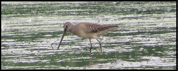
FALL DOWITCHER IDENTIFICATION
From early July through the first week of August, the Illinois dowitcher migration is owned by adult hendersoni SBDO in fresh breeding plumage. Don’t expect to see much of anything else. Moving forward to the second week of August through the third week of September, the Illinois dowitcher migration changes considerably and is then dominated by juvenile SBDO (but smaller numbers of worn adult SBDO and LBDO may also occur). With a decent view, juvenile SBDO may be easily identified by their tiger-stripe, orange-buff internal markings on the tertials and scapulars.
Juvenile SBDO, photographed by Kevin Karlson.
Beware of worn adults seen in August, as they are notoriously difficult to identify. The rounder shape of LBDO is helpful in distinguishing between the two species, but not always reliable.
Worn breeding plumage LBDO (left) and SBDO (right), photographed in August by Julian Hough.
From late September through October (and into November), juvenile LBDO (molting into the gray winter plumage) is the expected form in Illinois. These are very different in appearance from juvenile SBDO. They are overall grayish, with a gray breast and only a touch of orange on the belly. There are no tiger-stripe orange-buff internal markings on the tertials and scapulars, but the scapulars are clearly outlined with bright reddish chestnut, which is a diagnostic distinguishing mark.
Juvenile LBDO, photographed on 24 September 2016 in DuPage Co. by Davida Kalina.
Abigail Blake-Bradshaw, Grant Recipient by Ryan Askren
One of IOS’s objectives is “To promote scientific research and education in order to improve knowledge and awareness of birds in Illinois”. The IOS Grants Program was initiated several years ago to support this objective with funding.
The 2017 IOS Grants Program received nine requests for funding, representing a notably diverse set of study goals. The IOS review team evaluated each proposal, and determined that all were suitable for funding within the scope of that key objective described above. In addition to money provided directly by IOS, donations by five organizations and many individuals (see the alphabetical lists below) made it possible for all of the 2017 grant requests to be fully funded. A total of 94 Grants totaling $82,019 have been awarded since the program’s inception, through this year.
Jill Anderson
Paula Aschim
Denis Bohm
Margie Busic
Sonia Da Silva
Donnie Dann
Pen & Carl Daubach
Glenn Gabanski
Urs Geiser
Cynthia Gray
Eric Gyllenhaal
Tamima Itani
Janice Knight
Mary Krigbaum
Scott Latimer
Cindy Madsen
Vera Miller
Marsha Steffen
Dave Thomas
Ted Wolff
Chicago Ornithological Society
DuPage Birding Club
Kane County Audubon
Lake-Cook Audubon
McHenry County Audubon
Southern Illinois Audubon
Springfield Audubon
Starved Rock Audubon
Thanks to you all! Without the generosity of these organizations and IOS members and friends in the bird conservation community, IOS would not be able to support these projects. The support exemplified by this funding sends an important message to these students and researchers: We believe in your work, and we care about the future of our state’s bird life!
Thanks to Matt Igleski and Scott Meister for reviewing and evaluating all the requests.
Congratulations to the Grant recipients! Watch for their project articles in future issues of Meadowlark and watch for short summaries on the IOS website. Here’s a synopsis of the 2017 Grants. Where noted, individuals and organizations targeted those Grants for their donations.
Grant recipient, Heather Herakovich, by Dee Hudson
#
Amount
Name/Organization
Description/Sponsor
1.
$1,000
Abigail Blake-Bradshaw
University of Illinois Urbana-Champaign, Illinois Natural History Survey, and Forbes Biological Station
Wetland quality for waterbirds in Illinois. 3rd year of project; shorebird habitat usage added to project.
Sponsored by DuPage Birding Club.
2.
$1,000
Therin Bradshaw
Western Illinois University and Forbes Biological Station
Marsh bird use of wetlands managed for waterfowl in Illinois.
Sponsored by DuPage Birding Club.
3.
$100
Rachel DiPietro
Illinois State University
Constructing a data-based mortality profile for avian tower kills at telecommunication towers in Illinois.
Sponsored by IOS.
4.
$1,000
Heather Herakovich
Northern Illinois University
The effects of bison reintroduction, prescribed fire, and time since restoration on grassland birds in tallgrass prairie. 2nd year of funding.
Sponsored by IOS.
5.
$1,500
Maureen Hurd
University of Illinois Urbana-Champaign
Habitat use and foraging behavior of Chimney Swifts, a rapidly declining and poorly studied species.
Sponsored by Lake-Cook Audubon ($1000) and IOS ($500).
6.
$1,000
Alec Luro
University of Illinois Urbana-Champaign
The function of plumage color in American robins: why do males and females differ in appearance?
Sponsored by IOS.
7.
$1,000
James Marshall, Sean Beckmann, and Troy Skwor
Rockford University
Patterns of Borrelia burgdorferi infection and antibodies in birds of northern Illinois.
Sponsored by IOS.
8.
$1,050
John O’Connell
Southern Illinois University, Cooperative Wildlife Research Laboratory
Estimating wetland availability for inundation-dependent birds in Illinois.
Sponsored by IOS, Lake-Cook Audubon and Southern Illinois Audubon.
9.
$1,000
Heather Skeen
University of Chicago
Effects of seasonality and migration on the microbiome of Swainson’s Thrush.
Sponsored by IOS and McHenry County Audubon.
Black-bellied Whistling-Duck: Carroll (North) – On 22-Jul-2017, Ethan and Cindy Brown found a Black-bellied Whistling-Duck along Army Depot Rd. near the entrance to the Lost Mound Unit of the Upper Mississippi River National Wildlife Refuge in Carroll County.
Ruff: Mason (Central) – On 18-Jul-2017, Colin Dobson found a Ruff at the pool south of Chain Lake, at Sanganois State Fish and Wildlife Area in Mason County.
The American Ornithological Society (AOS) recently issued its 58th Supplement to its Check-list of North American Birds. Since the Illinois Ornithological Records Committee (IORC, a committee of the Illinois Ornithological Society) follows the AOS taxonomy in keeping the official Illinois State List of Birds, all relevant changes from the 58th supplement get reflected in the Illinois list. These changes are summarized below.
Thayer’s Gull was lumped into Iceland Gull. Thayer’s Gull thus no longer appears on the Illinois list.
The genus Chen was merged into Anser. Thus, Snow Goose and Ross’s Goose have a scientific name change, and they move ahead of Greater White-fronted Goose in the taxonomic sequence.
The puddle duck genus Anas was split into a few separate genera, and the taxonomic sequence of the species was changed. Garganey, Blue-winged Teal, Cinnamon Teal, and Northern Shoveler become part of Spatula; and Gadwall, Eurasian Wigeon, and American Wigeon become part of Mareca.
The sequence for the Sandpiper family (Scolopacidae) changed, resulting in Whimbrel moving ahead of Eskimo Curlew, American Woodcock moving ahead of Wilson’s Snipe, and Lesser Yellowlegs and Greater Yellowlegs swapping positions.
Northern Harrier was split into Hen Harrier (in the Old World) and Northern Harrier (in the New World). Our Northern Harrier retains its common name, but gets a new scientific name, Circus hudsonias.
Northern Shrike is split into Northern Shrike (New World and northeast Asia) and Great Gray Shrike (Old World). Our Northern Shrike retains its common name but gets a new scientific name, Lanius borealis.
The taxonomic sequence of the finch family (Fringillidae) changed.
Our sparrows and towhees were split out of the Emberizid family into a family all their own: Passerellidae, the New World Sparrows. The position of this new family is different in the new sequence.
The common name for Ammodramus leconteii changed from Le Conte’s Sparrow to LeConte’s Sparrow. This change was made to agree with how John Lawrence LeConte, after whom the sparrow is named, wrote his surname.
The Yellow-breasted Chat is moved out of the wood-warblers and into its very own family, Icteriidae, the Yellow-breasted Chats. Don’t confuse this family with Icteridae, the Blackbirds, in front of which the Icteriidae is positioned in the new taxonomic sequence. The Yellow-breasted Chat is the only species in the new family.
In addition to the Blackbird family being moved up in the taxonomic sequence, the order of the species within it also was changed.
The new taxonomic sequence, name changes both common and scientific, and the disappearance of Thayer’s Gull from the Illinois list are all reflected in an updated version of the Birds of Illinois.
Back on April 3, 2017, I was in a northeast Lake County area when I heard a loud, unusual bird chattering along with various birds and an Eastern Gray Squirrel running for cover. Suddenly, a Merlin came flying by, chasing after some prey. Over the next week, when checking on this area, I continued to see this adult male actively hunting, sometimes diving into suburban front yards, other times pulling up and perching in a nearby oak. At that time, I figured this male must be a late migrant, hindered from migrating by the ongoing strong north winds.
Investigating the area again on April 8th, I heard Killdeer distress calls, but to my surprise, I soon discovered it was the same male Merlin giving the calls, something I later understood was related to its nesting cycle. What transpired next stunned me. This male flew towards the top of a Bur Oak, whereupon it landed next to a female Merlin, who started to give repeated similar calls (but sounding more like a wounded Killdeer). It was a Merlin pair and they were clearly on a territory! Over the next half hour, I watched what I later realized was their courtship flight, the male, sometimes the female, circling in horizontal flight with fluttering wings, giving those Killdeer-like calls the whole time and overall having an appearance similar to flying Monk Parakeets.
As if this wasn’t exciting enough, at the end of one of his fluttering circles, calling the whole time, he then landed on top of the female and copulated for a second! Soon after, he did this again, staying for two seconds and prepared for this stunning event, I was able to secure the first Illinois photographs of copulating Merlins.
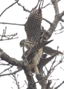
Immediately after the copulation, the male flew off, only to return soon after with a prey item (mouse or small bird), which it plucked its feathers/fur and then left the food item on a conifer branch, intended as dinner for its now established mate.
Merlin with Meal by Eric Walters
Merlins don’t make their own nests, instead using crow or hawk nests. In the alley behind the lookout oak perch tree was an active crow nest. This crow pair clearly was not sharing my excitement at the significant ornithological history occurring in their midst. Interestingly, I never heard the crows give any calls or attempt to drive away these Merlins. It almost seemed like they didn’t know exactly what these birds were, only that there was some form of danger in their midst, so they remained silent as they examined the situation. On the evening of the first copulation and dinner, I later saw the female Merlin fly up to this Norway Spruce and enter the crow nest. It looked like the Merlin’s were taking over the active crow nest and with copulation that afternoon, egg laying would be expected by the morning – the first confirmed Merlin active nest in Illinois history!
Nevertheless, at my next visit here, the crows had returned and were brooding on their nest. It looked like the crows might have won the skirmish over the rights to this nest. Meanwhile, the Merlins continued on for weeks to come, continuing to actively use the tall oak lookout perch, the male hunting and daily bringing food to the waiting female (a known courtship activity).
I visited this area a couple times at end of the day and found both Merlins quite active heading into sunset, using various tall tree perches together. I found them actively using the area more than half a mile to the west/northwest and half a mile to the south/southeast of the crow nest site.
This tall oak was in suburban front yard and was daily used as a lookout perch over the area, along with affording a view of the nearby nest. It continued as their main perch, at least until the oak leaves grew by the end of May. Also during April and May, adjacent to this Bur Oak lookout perch, another shorter tree was used as a feeding perch, easily confirmed by all the small feathers and white ‘splash’ beneath it. This tree was the end of the driveway, so many drivers passing by could have easily seen this Merlin perched and feeding.
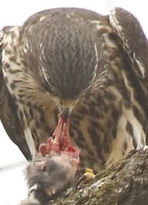
I personally saw kill items of a mouse, junco, sparrow (probable White-crowned), White-breasted Nuthatch and most amazing, both Chimney Swift and a Barn Swallow, all brought to the female to feed on. It was like the female did no hunting at all during this courtship period, perhaps a test to see if the male could regularly provide for her. Merlins are not like other falcons in their hunt technique. They sit on perches, often high up, where they can get a global view of the area and from where they can launch out on an attack, giving its ‘Killdeer’ like call as they fly horizontally with amazing speed, ultimately catching their prey. Catching a fast, agile Chimney Swift or Barn Swallow in flight were more than enough evidence to convince me of their amazing hunting abilities.
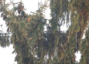
Merlin Nest by Eric Walters
But what of their breeding? Pair on territory, daily courtship routines, male feeding female multiple times a day, copulation seen at least four times by April 12th… yet still not official nest being used. Would this just go down as a failed dry run for this pair? After all, this was incredibly far south of their expected nesting range. In their normal range, I read that nesting typically started after the onset of May, so I had hopes things would turn around, especially as this pair continued to actively keep this small yard territory into May.
With the continued unseasonable cold weather and north winds into the second week of May, it was becoming apparent to me that the next strong southerly front would be the proof as to whether this pair was actually going to nest or if it was going to be recorded as a failed breeding attempt. I never did see the actual encounter between the crows and Merlins, if even there was one. The daily ‘pressure’ of having these falcons adjacent to their nest might have been too much for the crows and perhaps they voluntarily left. On the other hand, there could have been some sort of death skirmish. However it happened, by the second week of May, the crows had abandoned their nest in this Norway Spruce, setting up the possibility of the Merlins taking it over. Merlins like having a nest in an evergreen where they can fly in and land on the branch next to it, along with the nest providing a view of the larger territory surrounding it. They apparently don’t have to be high up, although this nest site would be considered on the high end, at least 60 feet up.
Male Merlin by Eric Walters
A strong warm front arrived by midday May 15th and either the Merlins perceived its arrival and began laying eggs (as early as May 9th, following a night of copulation and multiple feedings by male) or began immediately laying eggs the day after this warm front. Either way, I was able to happily confirm their return to this chosen former crow nest site by May 16th. This nest was so deep that the brooding female was typically not seen, only rarely a small portion of its tail sticking up out of nest. She typically revealed her presence when the male, with its high pitched calls, brought her next meal. On those occasions, the female left the nest, took the male’s catch and went to a nearby perch to feast. Meanwhile, the male actually went up to the nest and did nest brooding duties until the female had completed its meal. On one occasion, I saw the female get out of the nest and fly southeast, upon which the male came to sit on the nest, suggesting she did occasional hunting for herself.
With egg hatching taking about a month and fledgling an additional month, it appears as if mid-July would provide the first information on whether young will survive the nest. Fledglings are apparently fed by adults for another four weeks, so this nest story is expected to be complete by mid-August. If fledglings survive until next year, the hope is that this general area, with its expansive great habitat for what Merlins look for in nesting, could become an epicenter for their range expansion into Illinois. 2012 seemed to be a year of increasing reports from central Wisconsin, followed by three confirmed nesting in that region in 2015, along with an amazing two nests that summer on the north side of Milwaukee – less than 45 miles from the Illinois stateline!
With Merlins now sporadically nesting in the lower half of Wisconsin, along with ten Illinois June to July ebird Merlin records in the last 5 years, there’s already a suggestion that range expansion is already underway in various northern tier locations in our state.
Anhinga: Jackson (South) – On 10-Jul-2017, while looking unsuccessfully for the White Ibis, Craig Taylor photographed an Anhinga flying over Highway 3 in Jackson County. This bird has been in the area since the spring.
White Ibis: Jackson (South) – On 9-Jul-2017, Don Mullison discovered an immature White Ibis along Highway 3 south of Grand Tower.
Neotropic Cormorant: Kane (North) – Continuing a strong showing for this species this summer, Steve Bayer photographed a Neotropic Cormorant just above North Aurora Dam in Kane County on 9-Jul-2017.
White-winged Dove: Kane (North) – Also on 9-Jul-2017, Jay Sturner photographed a White-winged Dove at Dunteman Turf Farms in Kaneville, Kane County.
Wood Stork: Jefferson (South) – On 6-Jul-2017, Bob Gulledge reported a Wood Stork at Rend Lake near the Nason Observation Tower in Jefferson County.
Neotropic Cormorant: DuPage (North) – Add DuPage to the list of counties reporting Neotropic Cormorant this year. One was photographed at Fulmer Pond on 3-July-2017.
Tricolored Heron: Lake (North) – On 20-Jun-2017, a Tricolored Heron was photographed at the mouth of the Dead River at Illinois Beach State Park, South Unit.
White-winged Dove: Cook (North) – White-winged Dove made a brief appearance at a feeder in Cook County on 19-Jun-2017.
It is with great excitement that IOS announces an international trip to the tropical forests of Panama! IOS will be traveling down to Panama June 26th – July 5th, 2018 (Click Here for Itinerary). IOS is partnering with Josh Engel and his new tour company, Red Hill Birding, for what is going to be a trip that delights birders whether it’s your first trip to the tropics or your tenth (Register here).
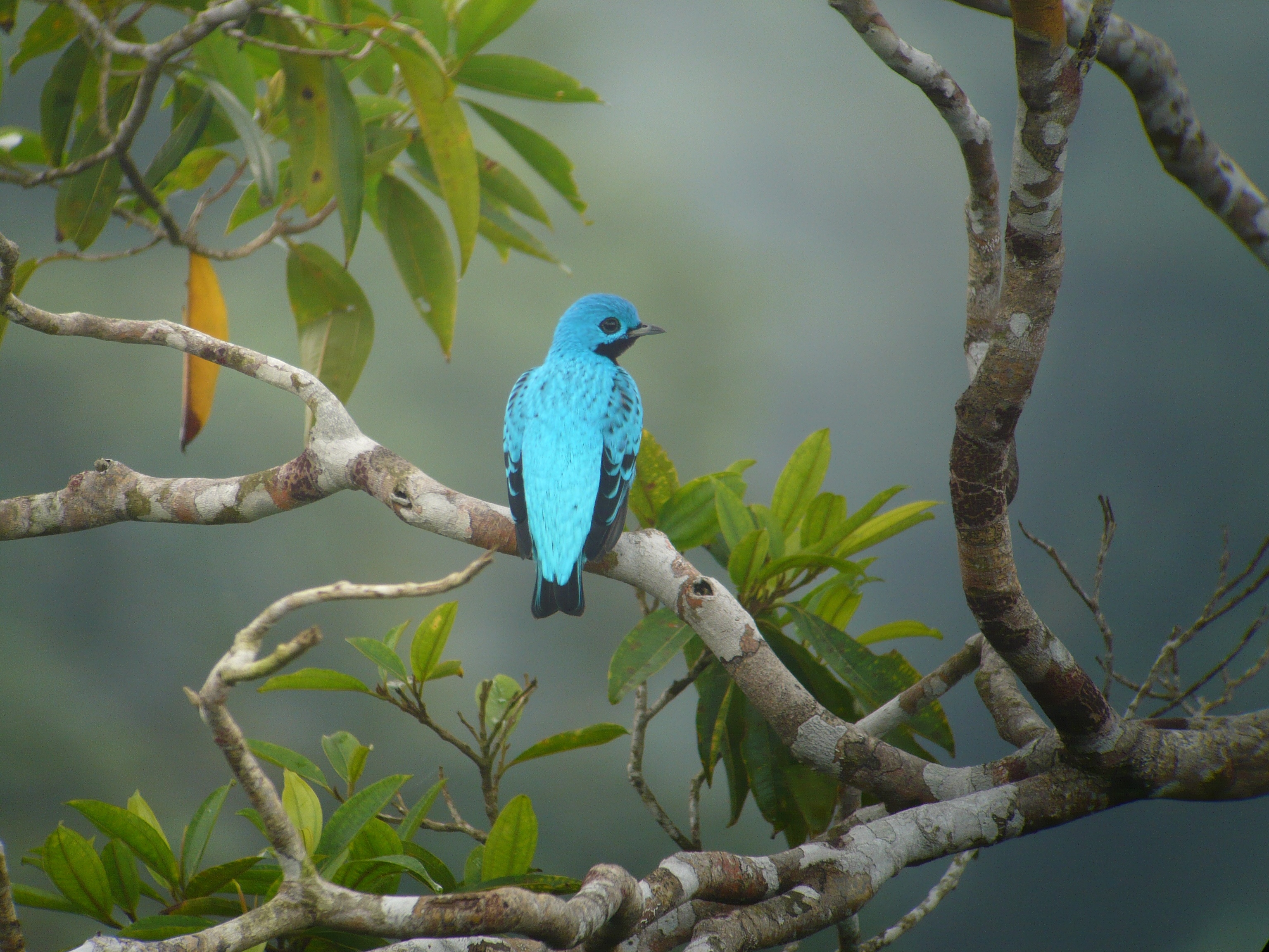
Male Blue Cotinga, courtesy of the Canopy Family
We will be staying in the Canopy Family’s now famous eco-lodges, the Canopy Tower in the central lowlands, and the Canopy Lodge in the foothills of El Valle de Antón. Due to the varied habitats we will visit, 260+ species can be expected, including members of some the most dynamic Neotropical families, like motmots, puffbirds, manakins, cotingas, antbirds, toucans, and many, many more! Oh, and over 20 species of hummingbird are possible!
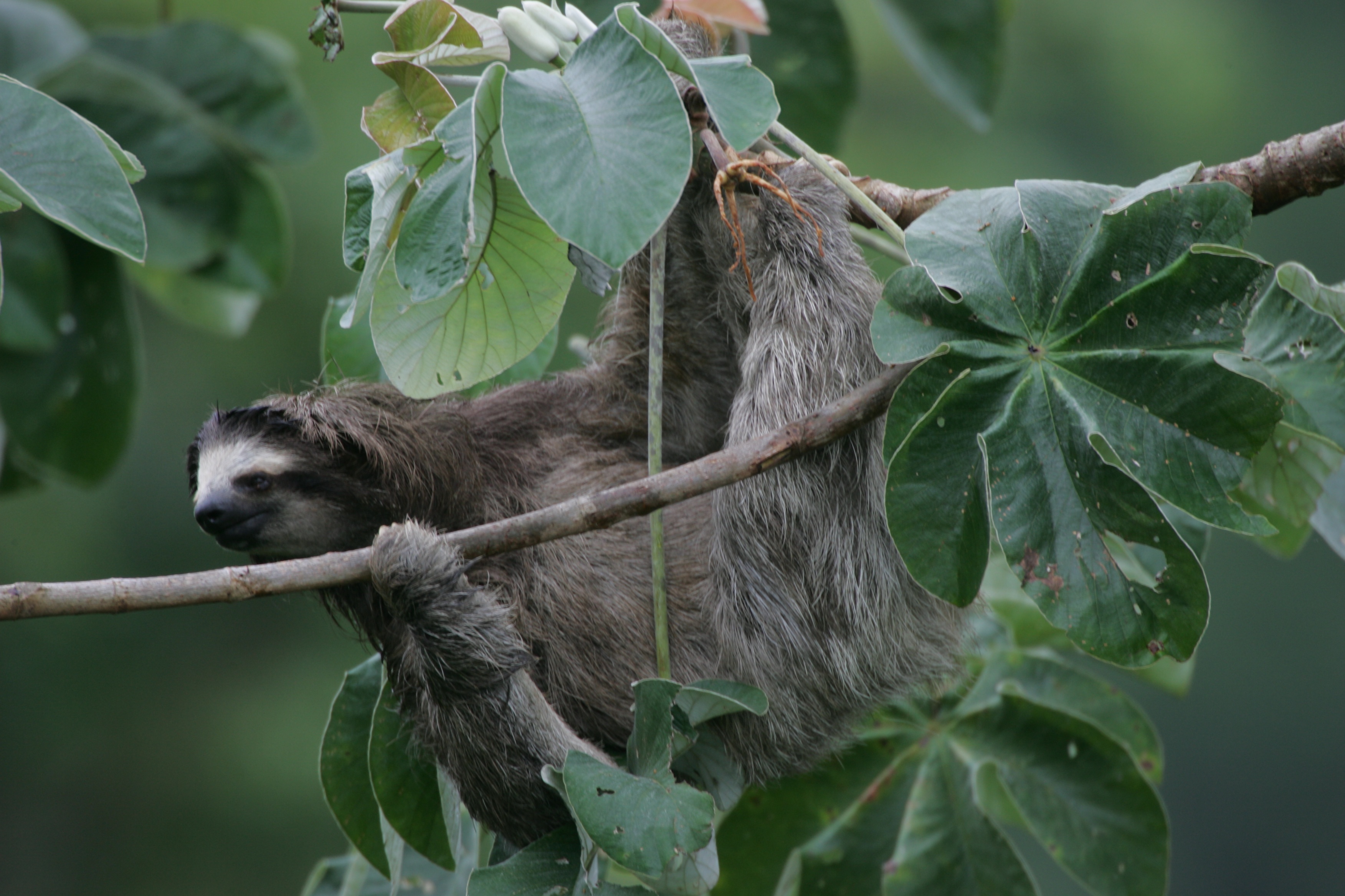
Brown-throated Three-toed Sloth from the Canopy Tower! Photo by Doug Weschler, courtesy of the Canopy Family
A post-trip extension (July 5th – July 11th, 2018) will have us traveling to the Canopy Camp, the Canopy Family’s newest location in the heart of Eastern Panama’s Darién Province! Here, we will enjoy a new host of birds, including many that are endemic to Panama or the Chocó biological region. It is at the Canopy Camp where we have the greatest chance of seeing a Harpy Eagle. We will devote an entire day to searching for Panama’s national bird!
Adult Harpy Eagle in the heart of the Darién. Photo by Ewe Speck, courtesy of the Canopy Family
This is an exclusive IOS members trip, and we look forward to seeing many of you in wonderful Panama next summer!
See the full itinerary, cost, and trip details HERE.
If you would like to register for the trip or have any other questions, you may contact Red Hill Birding and register HERE.
What is the Breeding Bird Survey and what does it do for the birds?
All of us reading this article enjoy birds and want to protect the birds and the places where birds live. One of the most important ways that we both protect birds and our environment is by monitoring bird populations. Unlike nearly all other taxa, birds can be effectively monitored across large geographic areas and over long periods, this is primarily because of the number of competent bird watchers that are willing to volunteer their time and expertise to monitoring birds.
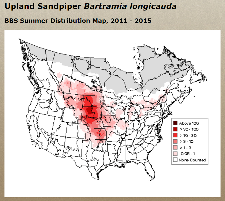
Relative Abundance Map for Upland Sandpiper
The primary program used to monitor birds in North America is the Breeding Bird Survey (BBS). The BBS started in 1966, at a point in time when the general public was greatly concerned about the health of the environment and birds were the way to monitor the environment. The BBS was one of the contributions provided by Chandler Robbins. Chandler Robbins recently passed away at 98 and was the key figure in the development and use of the BBS. (You can read more about him in this article by the Washington Post.)
The BBS has a rather simple protocol, the US Geological Service at Patuxent Wildlife Research Center randomly choose routes along rural roads. Each route is approximately 25 miles long and there are stops every ½ mile, at each stop a 3 minute survey is conducted and all birds within ¼ mile that are seen or heard are recorded. These routes are conducted from sunrise to about 9:00AM once per year. In Illinois we have 101 routes and in general they are conducted between late May and early July. While we, as a state, have improved the percentage of routes that are completed each year we still often have 8 to 12 routes that are not assigned to a person. This map provide the location of routes and which ones are available.
Why it is important
With the data collected from across North America over the last several decades, statisticians at Patuxent Wildlife Research Center use complex statistician approaches to model how the population of birds are changing. These population trend data are one of the key pieces of data used to determine conservation priorities at various organizations. For example, the US Fish and Wildlife Service use these data to determine priority species. Here in Illinois the Illinois Department of Natural Resources uses these data to help determine which species should be considered in greatest needed of conservation. Partners in Flight has recently produced a very interesting report, Species of Continental Concern, which primarily uses the BBS data.
The BBS data not only can be used to inform us about which species is increasing or decreasing, but the data provides the distribution of species. You can view Relative Abundance Maps for each species on the Patuxent Wildlife Research Center Web site.
With the distribution data we can further refine conservation priorities. For example, Illinois is an important area for Dickcissel and Henslow’s Sparrow because we are in the core area of their distribution and a relatively large percentage of their population is in our state. Therefore when determining how to use limited conservation resources we can have additional data to determine where the funds should be used.
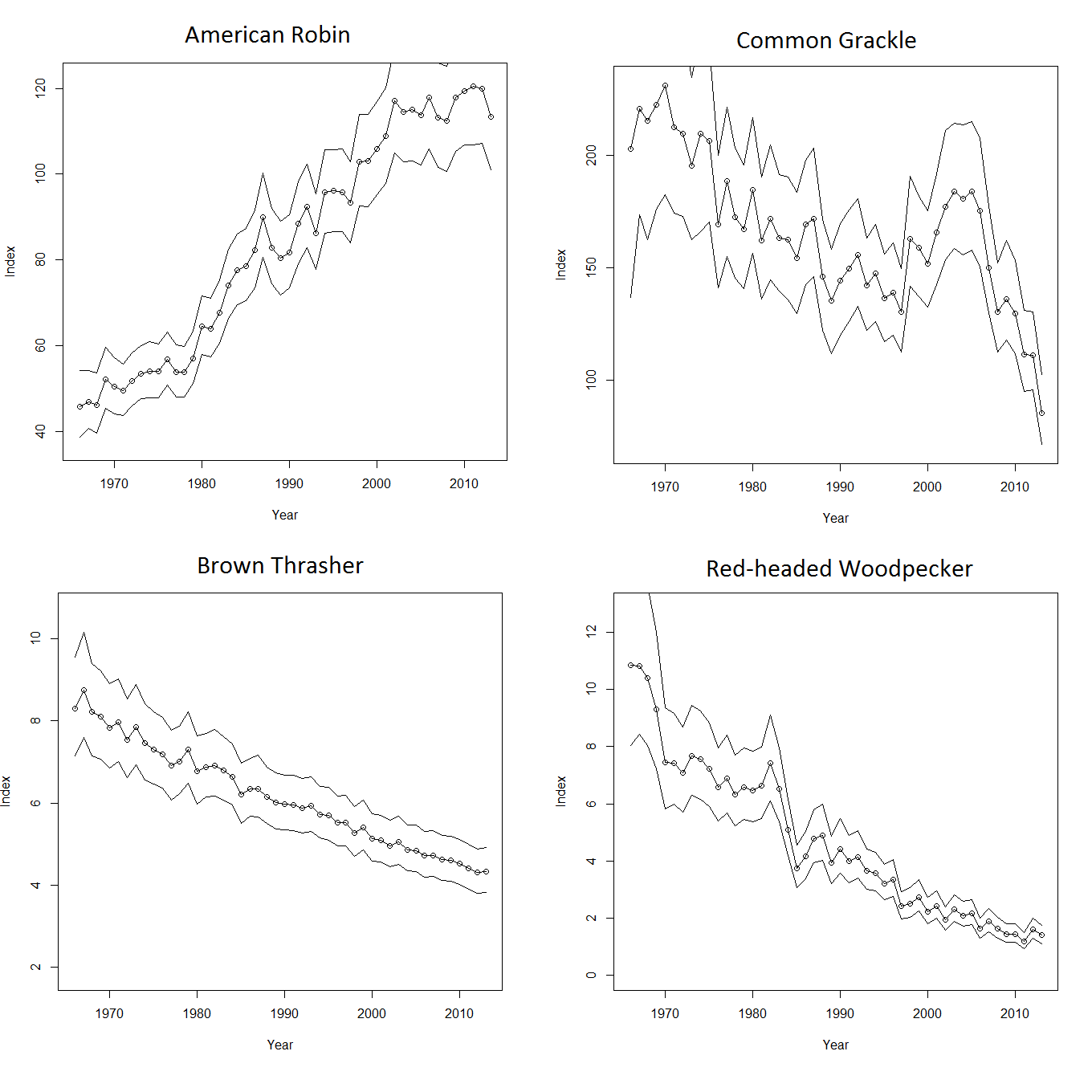
Finally, the BBS can provide the “large scale” view of how bird populations are faring. We all have our favorite areas to go bird watching, and these areas may or may not be representative of the greater population of a given species. In addition, there is a natural tendency for birdwatchers to be more interested in the rarer species. To this end many of us have noticed an increase in Henslow’s Sparrows over the last couple decades and the BBS survey also shows this increase. However, common species that are declining, often are not noticed by the casual observer. For example, if you look out your window right now you might see both American Robins and Common Grackles, both common species in the state, however their population trends are completely different. Where American Robins are exhibiting a steady increase in population, Common Grackles have been declining. Many people have remarked to me about the decline in Red-headed Woodpeckers and sadly the BBS also shows the same decline, however again species that are still relatively common such as Brown Thrashers are showing an alarming decline. The “take home” is that the BBS provides the data to accurately model the population of bird species and with these data we (the conservation community) can hopefully determine why the species is declining and then striving to either reduce or hopefully reverse the decline.
Trends in Bird Population
Involvement
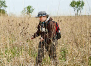
I (Mike Ward) am the BBS coordinator for the state of Illinois and therefore one of my responsibilities is to find competent volunteers that can identify the breeding birds of Illinois by sight and sound. Luckily we have many great volunteers in Illinois, but we could use more. It is likely too late to get people signed up for the 2017 breeding season but we will need more people in 2018. Given my career, I work with BBS data often and I often get firsthand experience regarding how important these data are to the conservation planning process. For a different perspective of the BBS I asked a volunteer to provide their impression regarding the data collection process and Ray Boehmer, an IOS member from Urbana, was gracious enough to provide the following:
“I have been doing Breeding Bird Survey (BBS) routes for eight years, starting with one, adding another a couple years later, and then adding a third route this year. Birding is normally a relaxing, low-intensity activity for me, but doing a BBS “kicks it up a notch.” At each of the 50 stops, I have to be alert and on my toes to record every bird seen or heard. It reminds me that I am taking part in the scientific aspects of birding. I have to be as objective and accurate as possible. I really like that about participating in the BBS program.
The starting points for my routes range from 30 minutes to a little more than an hour from my house. So having to get up early is an understatement. But I have always been an early riser, so a 3 AM alarm is not too bad.
My routes mostly go through agricultural areas, with a surprising number of wooded creeks crisscrossing, providing some fairly “birdy” stops. In one 3-minute count, I managed to record 35 individuals representing 15 species. That was intense! Then quickly on to the next stop.
The people organizing, supporting, and promoting the BBS program, at both state and federal levels, are well qualified and easily accessible, making the effort on my part about as easy and smooth as I could possibly want. Recording and submitting the results are easy and user-friendly. I plan to continue participating in the BBS program as long as I can while my vision and hearing remain sharp.”
If you are interested in conducting a BBS route please contact Mike Ward.